What drone technologies capture Cultura aerial heritage footage
The preservation of cultural heritage is a global priority, and documenting its often fragile state is crucial for future generations. Traditionally, aerial photography for heritage sites relied on manned aircraft, a process that was both expensive and logistically challenging. However, the rise of drone technology, or Unmanned Aerial Vehicles (UAVs), has revolutionized this field, offering a more accessible and versatile solution for capturing high-quality aerial footage. This article explores the key technologies driving this transformation and how they’re being used to document and protect our world’s cultural heritage.
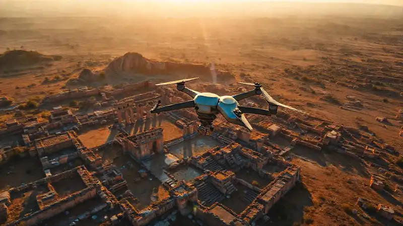
The unique ability of drones to access difficult-to-reach locations, operate at lower altitudes, and gather data quickly makes them ideally suited for heritage documentation. They are rapidly becoming indispensable tools for archaeologists, architects, historians, and conservationists, allowing them to create detailed 3D models, orthomosaics, and other valuable datasets. This shift is not just about collecting images; it's about enabling new research methodologies and informing conservation strategies, ultimately contributing to the longevity of these invaluable sites.
## Drone Platforms and Stability Systems
The foundation of any successful aerial heritage capture is the drone platform itself. Currently, a range of drones are used, from smaller, consumer-grade models to larger, industrial-grade systems. Smaller drones offer portability and ease of use, ideal for quick surveys and smaller sites, while larger drones provide greater payload capacity for heavier cameras and sensors. Choosing the right platform requires careful consideration of factors like flight time, wind resistance, and the weight of the equipment.
Stability is paramount for capturing sharp, detailed imagery, especially when dealing with intricate architectural features or archaeological remains. Early drone systems struggled with vibration, resulting in blurry photos. Modern drones incorporate sophisticated stabilization systems, including gimbal technology, which uses motors and sensors to counteract movement and maintain a level camera orientation. Advanced systems even employ inertial measurement units (IMUs) and GPS to compensate for wind gusts and ensure smooth footage, regardless of external conditions.
Furthermore, the increasing use of RTK (Real-Time Kinematic) and PPK (Post-Processed Kinematic) GPS systems are significantly enhancing the accuracy of drone positioning. These technologies allow for georeferenced imagery and 3D models with centimetre-level precision. The integration of these positioning capabilities dramatically improves the usefulness of the data for archaeological analysis and accurate site mapping.
## Camera Systems: Resolution, Sensors, and Lenses
The quality of the camera is arguably the most critical factor in producing valuable heritage footage. Initially, drones often used standard consumer-grade cameras. However, the demand for higher resolution and specialized sensors has spurred a significant evolution in drone camera technology. Today, we see widespread use of high-resolution RGB cameras capable of capturing images with millions of pixels, allowing for incredibly detailed visualizations and the extraction of subtle features. Multi-spectral cameras are also gaining popularity.
Beyond standard RGB, specialized sensors like thermal cameras are proving invaluable for identifying buried archaeological features. Thermal imaging detects variations in ground temperature, which can reveal anomalies that indicate the presence of walls, foundations, or other buried structures. LiDAR (Light Detection and Ranging) is another crucial sensor, emitting laser pulses and measuring their return time to create highly accurate 3D point clouds, effectively penetrating vegetation and revealing underlying topography.
Lens selection also plays a vital role. While wide-angle lenses are useful for capturing expansive views, they often introduce distortion. For detailed documentation, prime lenses with lower focal lengths and minimal distortion are preferred. The ability to swap lenses to optimize for specific conditions and capture requirements adds further flexibility to the heritage capture process.
## Photogrammetry and 3D Modelling Software

Raw aerial imagery is rarely the end product. Photogrammetry, the science of extracting 3D information from photographs, is a core technology in heritage documentation. This process involves taking numerous overlapping images from different angles and using specialized software to reconstruct a three-dimensional model of the site. The accuracy of the resulting 3D model hinges on the quality of the imagery and the precision of the drone's positioning, highlighting the synergy between the hardware and software components.
Numerous software packages are now available for photogrammetry and 3D modelling, ranging from free open-source options to powerful commercial solutions. These programs automate many of the processing steps, including image alignment, point cloud generation, and mesh creation. Advanced software allows for texture mapping, enabling the creation of realistic and visually compelling 3D models that can be used for virtual tours, detailed analysis, and preservation efforts. The use of artificial intelligence is increasingly integrated into these software packages, automating tasks such as feature extraction and object recognition.
The resulting 3D models offer unprecedented opportunities for heritage research. Researchers can virtually explore the site, measure distances and elevations with great precision, and analyze architectural details in ways that were previously impossible. These models can also be used to create interactive experiences for the public, bringing cultural heritage to life in a new and engaging format.
## Data Management and Preservation Strategies
The sheer volume of data generated by drone-based heritage documentation requires robust data management strategies. Raw images, point clouds, and 3D models can quickly consume significant storage space, necessitating efficient organization and archiving systems. Metadata, including information about the drone model, camera settings, and flight parameters, is crucial for ensuring the long-term usability of the data.
Cloud-based storage and collaborative platforms are increasingly common for managing and sharing heritage data. These platforms allow researchers from different institutions to access and work on the same datasets, facilitating collaboration and accelerating research. Secure data backups are essential to protect against data loss due to hardware failure or other unforeseen events. The implementation of clear data archiving protocols is critical for ensuring the accessibility of this valuable resource for future generations.
Ultimately, the successful application of drone technology in heritage documentation requires a holistic approach that considers not only the technology itself but also the data management, preservation, and ethical considerations involved. Developing best practices for data handling and sharing is essential to maximize the benefits of this transformative technology.
## Conclusion
Drone technology has undeniably transformed the landscape of cultural heritage documentation, providing researchers and conservators with powerful new tools to capture, analyze, and protect our shared past. From initial surveys to detailed 3D modelling, drones are enabling a more comprehensive and accessible understanding of heritage sites worldwide. The ongoing advancements in drone platforms, camera systems, and processing software promise even greater capabilities in the years to come.
Looking ahead, the integration of artificial intelligence and machine learning into drone workflows will further automate data processing and enable new research possibilities. Continued refinement of data management and preservation strategies will be essential for ensuring that these valuable datasets are accessible and usable for generations to come. The responsible and ethical application of drone technology holds immense potential for safeguarding our cultural heritage and sharing it with the world.
Deja una respuesta